You’ve probably seen that neat white stripe tourists love to stand on—the “Equator line,” slicing across plazas and photo spots. A simple painted line, yet behind it lies humanity’s most profound attempt to understand the shape of our planet. The real equator isn’t visible, and its position was not always certain. Today we know it as Earth’s largest circumference, fixed halfway between the poles, a zero-degree latitude defined with centimeter-level precision by GPS. But the story of how we located this invisible line is an epic—one filled with sacrifice, conflict, and unfulfilled ambition. And it all began with one ancient question: What shape is Earth?
An Ancient Question: What Shape Is Earth?
Around 240 BCE, the Greek scholar Eratosthenes made a stunning breakthrough: he measured Earth’s circumference using nothing more than shadows cast at noon in two Egyptian cities. His calculation—roughly 40,000 km—was astonishingly accurate, within 1% of the modern value. This firmly cemented the idea of a spherical Earth. Yet a lingering puzzle remained: Is Earth a perfect sphere, or is it slightly deformed?
In 1687, Isaac Newton, in his Principia, proposed an answer. Earth’s rotation produces a centrifugal force that pushes material outward at the equator, making the planet slightly flattened at the poles. Newton’s theory was elegant, grounded in physics—but lacked direct measurement. And if Earth truly bulged at the equator, then the exact location of the equator—the largest circle of Earth’s geometry—needed to be discovered with precision.
In the age of sea travel, accurate maps meant survival. Maps relied on coordinates; coordinates relied on the true position of the equator. A deviation of just a few kilometers could send ships off course, costing cargo and lives. Navigators desperately needed answers—and France’s Academy of Sciences decided to take action.
1735: An Expedition That Would Change the World
In 1735, the Academy assembled a scientific expedition to determine the true length of one degree of latitude at the equator. This would be compared with European measurements to confirm whether Earth was flattened at the poles.
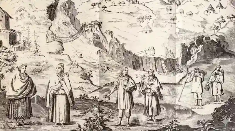
The expedition leader was Charles Marie de La Condamine, a 34-year-old mathematician. Joining him were astronomers Pierre Bouguer, Louis Godin, and two Spanish naval officers sent to supervise on behalf of the Crown: Jorge Juan and Antonio de Ulloa.
They carried into South America instruments the region had never seen: telescopes, quadrants, zenith sectors, custom-made metal measuring rods, and pendulums for gravity studies—tons of equipment forming a mobile fortress of science.
Their destination was the equatorial highlands of what is now Ecuador, then under Spanish control. The Crown permitted the mission—but assigned its own scientists to watch every step. After an eight-month journey, the team finally reached Quito in March 1736. Glory did not await them—hell did.
The Plan
On paper, their plan seemed straightforward:
- Select two points roughly three degrees of latitude apart (about 330 km).
- Measure the ground distance between them using six-meter metal rods.
- Determine the angular difference by observing the positions of specific stars.
- Calculate the Earth’s radius at this latitude and compare it with French data.
If the equatorial radius was larger, Newton was right.
The northern point was set near Quito; the southern point lay across a brutal landscape: ravines, cliffs, raging rivers, and icy peaks. La Condamine climbed mountains over 4,600 meters high to establish triangulation points. The thin air left him dizzy, sick, and exhausted. On these peaks, the team erected wooden towers as reference points for long-distance angular measurements.
Terrain was merciless. Torrential rains ruined instruments; lightning struck metal towers; illness stalked the group.
Over three years, they built 13 triangulation towers, each taking weeks of labor.
1737: Tragedy Strikes
In August 1737, disaster struck. Team member Jean Godin des Odonais’s cousin was killed trying to defend a local woman during a street assault. He was stabbed repeatedly and died at just 38. The mission nearly collapsed. Morale crumbled, and many French members wanted to return home.
La Condamine refused.
“The mission must be completed. We must fulfill our purpose.”
His resolve kept the expedition alive.
Internal Conflict: Sacrifice and Betrayal
By 1739, a new threat emerged—ego.
Arguments over credit split the team. Bouguer and La Condamine became bitter rivals. Cooperation disintegrated. Although they continued the project, they barely spoke, working independently and sharing data only when unavoidable.
The atmosphere was suffocating; trust was gone.
Yet, after years of toil, they finally produced results:
- Ground distance: 332,728 meters
- Angular difference: 3° 07′
The calculations showed the equatorial radius was indeed larger than the polar radius.
Newton was right.
Earth is an oblate spheroid. The equator is the planet’s widest circle—zero degrees latitude.
Using stellar observations, La Condamine marked the equatorial line near Quito with under 100 meters of error, an extraordinary achievement for the 18th century.
The Amazon Odyssey
With the mission complete, La Condamine refused to return to France by the same route. Instead, he embarked on a daring side-quest: to explore the Amazon River.
He built rafts and floated downstream for four months, measuring river widths, depths, currents, and collecting biological specimens. At each location he recorded latitude. When the river crossed the equator, he made a second equator measurement—less precise, but confirming the main result.
In September 1743, after traveling 5,000 km, he reached the Atlantic.
Rivalry and Ruin
Meanwhile, Bouguer rushed home and published his own findings in 1744, claiming priority. When La Condamine returned months later, he was furious. Their feud lasted years until Bouguer died in poverty in 1758 at age 60—never reconciled.
The story of Louis Godin was even darker. He remained in South America, married a Peruvian woman, and started a family. In 1749, while returning with his relatives, he vanished in the jungle. His wife Isabel mounted a desperate rescue with 30 people. After 45 days, she staggered back alone—starving, delirious, half-insane. No one else returned. Godin reappeared mysteriously twenty years later; how he survived is unknown.
Isabel became a public figure after reaching France, but her mind never recovered. She died in 1792.
The expedition lasted ten years. Of the original eleven members:
- Three died
- One went mad
- Two went bankrupt
- Friendships shattered
- Careers shattered
La Condamine himself died poor in 1774 at age 73, still defending his findings.
The Equator Moves, but Science Endures
The expedition’s legacy endures.
By 1792, new French surveys confirmed the difference between equatorial and polar radii: 21 km.
By 1899, improved instruments reduced Ecuador’s measurement errors to under 50 meters.
Modern science shows the equator isn’t fixed:
- Polar motion shifts Earth’s axis by meters per century
- Tectonics raise or lower the crust—La Condamine’s original site has risen by 2 meters
Today, satellites and GPS define the equator with centimeter accuracy, built on the same triangulation techniques used in 1736.
In 1958, the WGS84 system mathematically defined Earth’s dimensions:
- Equatorial radius: 6,378,137 m
- Polar radius: 6,356,752 m
- Difference: 21,385 m
Every time your phone shows latitude 0°, it echoes that blood-soaked expedition.
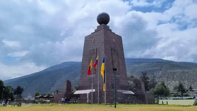
Even the famous “Middle of the World” monument in Quito is wrong—off by 240 meters, built in 1936 with outdated data. The true equator runs through a nearby museum that few tourists visit.
Equator monuments worldwide—in Uganda, Indonesia, Brazil, Gabon—are uneven in accuracy, but all trace back to that historic survey.
Precise equator data revolutionized navigation, aviation, and later satellite technology. A 10-km error could cause signal drift, delays, or expensive orbital corrections.
The equator hosts its own wonders:
- Maximum centrifugal force makes objects weigh 0.5% less
- On equinox days at noon, a vertical pole casts no shadow
- Myths like “water swirling differently” or “eggs stand upright” are false—the science itself is far more fascinating.
A Line Measured with Blood
The costs were severe—death, madness, financial ruin, broken friendships.
But the reward was monumental.
An invisible line became the backbone of modern civilization, measured through jungles, mountains, storms, and human conflict. The equator, once only a geometric idea, became a precise global coordinate—etched into our maps, our satellites, and our phones.
The explorers’ footsteps faded, but their legacy didn’t.
The line they revealed—hidden, eternal—still spans the Earth, a reminder that science often advances on the edge of human suffering and brilliance.
Their journey carved an invisible axis into our world—one measured not in chalk or paint, but in courage, obsession, and an unyielding hunger to know the truth.


